Algiers
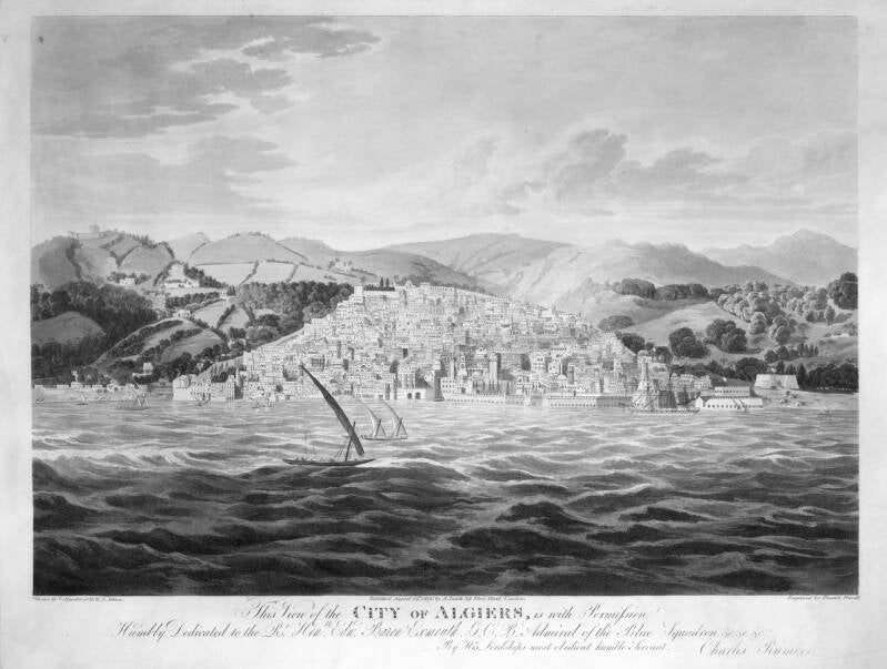
View of Algiers, by Charles Rumker (1816)
Algiers is built upon the slopes of the Massif Mountains (the northern Lesser or Tell Atlas), which run parallel to the Mediterranean coast, and stretches for approximately ten miles along the Bay of Algiers. The city faces east and north, and owes its name (Arabic: “The Islands”) to several small islands that once lay in the bay, all but one of which have since been connected to the mainland or erased by harbour works.
The city has a long and turbulent history. It was founded by the Phoenicians as one of their many North African colonies. It later became part of the Carthaginian Empire, but came under Roman influence in 202 BC. The Romans called it Icosium. This lasted until AD 429, when the Vandals sacked the city. The Byzantine-Roman general Flavius Belisarius (500–565) defeated the Vandals in 533, but in practice gained control over little more than a number of coastal towns and several inland settlements. The indigenous Berber population continued to resist the invaders, while Byzantium made itself unpopular through heavy taxation.
After a period of decline, the city revived once more. Under the military commander Uqba ibn Nafi al-Fihri, the Islamisation of North Africa began. From 669 onwards he advanced westward across North Africa and founded the first major Islamic city in the Maghreb, Al-Qayrawan — present-day Kairouan in Tunisia. By 698 the last remnants of Byzantine rule had disappeared, and by 712 the entire region, from Andalusia in Spain to the Levant, was under the control of the Umayyad caliphs.
Uqba’s successor, Abu al-Muhajir Dinar, was responsible for introducing Islamic law in Algeria, converting the Berbers, and appointing Umayyad governors to rule eastern Algeria. Despite their conversion to Islam, however, the Berbers remained loyal to their own culture and resisted the Arabisation of their lands.
In the tenth century, power in North Africa passed to the Berber Zirid dynasty (972–1148). Under their rule, Algeria emerged for the first time in history as an independent regional power. Algiers grew into an important commercial port.
In the early sixteenth century, large numbers of Muslims and Jews expelled from Spain sought refuge in Algiers, greatly increasing the city’s commercial activity. Around the same time, piracy against Spanish merchant shipping in the Mediterranean began to flourish. The Spanish responded by seizing and fortifying the small island of Peñon in the Bay of Algiers (1514), prompting the Algerians to seek assistance from Turkish corsairs. One of them, the notorious Barbarossa (Khayr al-Dīn), not only succeeded in recapturing Peñon from the Spanish, but also seized Algiers itself in 1529.
From that moment onwards, the city was placed under the authority of the Ottoman sultan, although in practice it remained largely autonomous. Following Barbarossa’s conquests, Algiers developed into one of the most notorious corsair strongholds of Barbary.
Sources: Landenweb, Wikipedia, Delphipages


Algiers in de 17th century, map by Cornelis Goliath (1617-1660)
Algiers in de 19th century
The European powers repeatedly made futile attempts to defeat the corsairs, including naval expeditions by the Holy Roman Emperor Charles V in 1541, and by the British and the Dutch during the seventeenth, eighteenth, and nineteenth centuries. Only in 1816 did the bombardment of Algiers by a combined British and Dutch fleet bring an end to the Algerian slave trade.
In 1830, the city was captured by the French, who transformed it into the military and administrative headquarters of their colonial empire in North and West Africa.
The Harbour
After the conquest of Algiers by Barbarossa, the harbour of the city was rapidly fortified. The small island of Peñon, upon which the Spanish fort had been built, was connected to the mainland by means of a rough pier. An old source describes it as follows:
“This connection between the city and the island of Peñon had been crudely constructed, consisting of enormous boulders of some forty tons each, hurled more or less at random upon and beside one another. Veenboer’s captives witnessed how at least five hundred slaves were needed to move a single block from the shore onto a lighter before it could be dumped into a weak section of the dam. A wall had been erected along the pier, and beside it a rough stone road led into the city.”
This pier, locally known as the Khayr ad-Din Barberousse, is referred to in all later Dutch sources as the moelje (according to the Military Dictionary of 1861: “a moelje may advantageously serve for defensive purposes. Peninsulas and islands before the roadstead provide opportunities for the construction of separate forts”). It was therefore an important fortification, providing the corsair vessels of Algiers with a protected anchorage.
A second line of defence was formed by the harbour itself. Even before the city walls, a high fortified wall was constructed along the entire waterfront, equipped with positions for heavy-calibre artillery. From the sea, the city became virtually impregnable — as history would prove: for nearly three hundred years, it successfully resisted attacks by British, French, and Dutch naval squadrons.
Sources: Morphological Evolution of the Port‐City Interface of Algiers, NEDERLANDERS ONDER DE BARBARIJS/TURKSE ZEEROVERS

Peñon,before the construction of the harbour. Source: Morphological Evolution of the Port‐City Interface of Algiers
The City

From the landward side, Algiers was protected by a high encircling city wall with bastions and round towers (the “Almohad”), while at its highest southern point stood the massive fortress of Masourah, defended by numerous cannons. Several additional fortifications guarded the approach roads leading into the city.
The city itself was divided into a lower quarter (Al-Wata) and an upper quarter (Al-Gabal), separated by a main east–west thoroughfare that connected the city’s only two gates (see map). The oldest district, the Kasbah, was located in Al-Gabal.

View of the east gate: Bab Azoun
The Kasbah
The Kasbah of Algiers is a unique form of medina — the oldest quarter of an Islamic city. Situated in the upper part of Algiers, it consists of a labyrinth of squares, alleys, stairways, and narrow lanes lined with houses and mosques: the Ketchaoua Mosque (built in 1794 by the Dey Baba Hassan), flanked by two minarets; Djama’a al-Djedid (1660, dating from the Ottoman period), distinguished by its large finished egg-shaped cupolas and four domes; Djamaâ el Kebir (the oldest of the mosques), built by the Almoravid ruler Yusuf ibn Tashfin; and the Ali Bitchin Mosque (Raïs, 1623).
The Kasbah also contained several palaces, including Dar Aziza, Dar Mustapha Pacha, the Palace of the Dey, and Dar Hassan Pacha, which was built in 1791 to house the Pasha, who resided there for eight years.
The Kasbah played a central role during the Algerian War of Independence (1954–1962). During the early years of the conflict, it served as the epicentre of the uprising led by the National Liberation Front (FLN), from where attacks against French civilians and law enforcement personnel in Algiers were planned and carried out. In response, the French authorities launched extensive operations in the Kasbah during the Battle of Algiers.
In 1992, the United Nations Educational, Scientific and Cultural Organization (UNESCO) declared the district a World Heritage Site.
Despite the district’s immense historical value, the Reuters news agency reported in August 2008 that the Kasbah had fallen into a state of neglect and that certain areas were in danger of collapse. Algeria’s national preservation agency, the ANSS, stated that 373 buildings in the Kasbah had already collapsed. Of the 1,816 buildings still standing, 40 percent were ruined or in critical condition, while another 10 percent had been boarded up.
The Algerian authorities cite age, neglect, and overcrowding as the principal causes of the district’s deterioration. Overcrowding in particular makes the problem difficult to resolve because of the challenge of relocating residents. Estimates vary between 40,000 and 70,000 inhabitants, though the number is difficult to determine with certainty due to squatters occupying abandoned buildings. One of the reasons the government seeks to improve conditions in the Kasbah is that it is regarded as a potential refuge for criminals and terrorists.
Source: Place and See
About the state of the Kasbah. Source: France24
The Palace of the Dey: El-Djenina
The Palace of El-Djenina was the residence of the Dey and stood at the heart of the Kasbah of Algiers. Its oldest section dated back as early as 1519. Over the centuries it successively served as the seat of the emirs (1519–1585), the pashas (1585–1659), the aghas (1659–1671), and finally the deys (1671–1817).
As the threat posed by rival factions steadily increased, the last dey, Ali Khodja, sought refuge in 1817 within the citadel of the Kasbah, which offered greater protection. It proved of little use, however, for he died of the plague in 1818. The French occupied Algiers in 1830, and in 1857 they demolished the palace to make way for a military barracks.
Thomas Hees, one of the principal characters in the book, was summoned to El-Djenina on many occasions; he still witnessed with his own eyes the splendour of its interiors and inner gardens.


Two images of El-Djenina. On the right, the last known photograph (1856), taken shortly before its demolition. The clock in the tower was installed by the French after 1830.
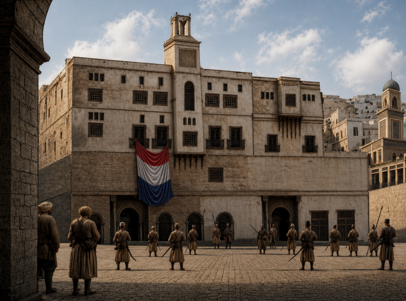
Reconstruction of El-Djenina. The scene is set in April 1679, when the Dutch concluded a peace treaty with the rulers of Algiers.
The Bagnos of Algiers
The majority of the white slaves were housed in special prisons known as bagnios. The word bagno is Italian and means “bathhouse”; according to one theory, captives during the early years of Barbary corsair activity were confined in former bathing facilities. A bagno typically consisted of an enclosed courtyard surrounded by cells or small chambers.
As far as is known, there was only a single bagno in Algiers in 1531: that of Barbarossa. But their number steadily increased. “There they keep the Christian captives under lock and key,” wrote Miguel de Cervantes, who himself was imprisoned in Algiers from 1575 to 1580.
“Those belonging to the king as well as to other masters, and also those of the almacén, as they are called — meaning the captives of the municipality, who serve the city in public works and other labour. These captives can scarcely ransom themselves, for since they belong to the public and have no private master, there is no one to negotiate their ransom, even if they should possess the means. To these bagnios certain private citizens of the town also send their slaves, especially when a ransom is expected for them, since there they may be kept safely and securely.”
By the seventeenth century, there were at least eight large bagnios in Algiers. The largest was the bagno grande del rey, where the slaves belonging to the Dey were held. Slaves owned by private individuals were also housed there. For this privilege, their owners paid a fee to the gardianes, guards who operated under the authority of the chief overseer, the guardian pasha. Between 1,500 and 3,000 people were confined in the bagno grande. The other state prison was the bagno de la bastarda (the prison in the book where Sniffer and Hansum Han are held; see the city map above), which accommodated approximately five hundred captives.
The bagnios were all constructed according to a similar design: a large central courtyard with a reservoir of fresh water, surrounded by galleries of cells on several levels.
It should be noted that during the daytime the bagnios were not closed prisons. Slaves who were not required to work were free to move about the lower quarter of the city (Al-Wata) from sunrise until sunset, provided they obeyed strict regulations. They were required at all times to wear an iron shackle around one ankle and, upon the approach of Muslims, to step aside, remove their head covering, and avert their gaze. Slaves who attempted to leave through the city gates were executed without mercy.
Text partly based on: Sultans, Slaves and Renegades: The Hidden History of the Ottoman Empire; other sources: Historiek.
Text partly based on: Sultans, slaven en renegaten: de verborgen geschiedenis van de Ottomaanse rijk; other sources: Historiek,

No trace remains of the bagnios of Algiers. A building that perhaps comes closest to their appearance is the Mendresses Ottoman (Prison de Leonardos) [18th century] in the Greek city of Nafplio.

The Port of Algiers, with the Jamaa Al-Jdid and Jemaa Kebir Mosques (1843), painting by Niels Simonsen (1807-1885)